


 Join/Renew
 Donate
 Volunteer
 Maps
Maps Newsletter
 Facebook
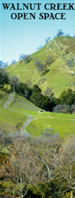
Walnut Creek Open Space Maps
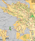
The City of Walnut Creek provides a free map of the Open Spaces which can be picked up at City Hall and during special events. These maps show entrances, ranger stations, facility locations, parking, and TRAILS. There are miles of trails crisscrossing our Open Spaces for you to enjoy.Note: The PDF documents below are large and may take a few minutes to load depending on your connection speed
 Full Open Space Map [PDF]
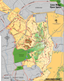 Map of Lime Ridge and Acalanes Ridge [PDF]
 Map of Shell Ridge and Sugarloaf [PDF]
View Walnut Creek Open Space Entrances in a larger map