


 Join/Renew
 Donate
 Volunteer
 Maps
Maps Newsletter
 Facebook


Fossil Hill Nature Trail Map
Fossil Hill Nature Trail
Start at the Sutherland Drive Entrance to Shell Ridge Open Space.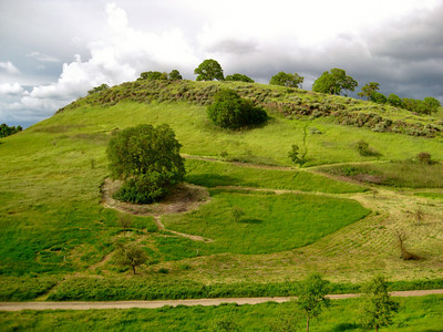
Fossil Hill
This is a guide to the area around the hill standing in front of you. It is called Fossil Hill. The easy walk for this Nature Trail takes about an hour or more and ends up back here; you will be making a loop by turning right at every junction. This article discusses the geology, flora and things that are most common in this area.
For information on our restoration efforts in this area check out our Fossil Hill Project Page.
You are now in the Shell Ridge portion of Walnut Creek's Open Space areas. Originally, this area was slated for homes and condos and even a shopping center, but a group of citizens put the development issue up to the voters in 1974 (see our History page). The vote was to buy the land so the people in this entire area would be able to use this Open Space for centuries to come. (Wow!)
Look around you. Everything you see was once under the sea. You are now standing about 310 feet above the present level of the sea even Mt. Diablo at 3849 feet was once beneath the sea. The highest portion of Shell Ridge is some 829 feet high and it, too, was once below the sea surface. Tectonic forces caused by the overriding of the Pacific Plate by the North American Plate caused this uplift along with compressional forces that have tilted the once-horizontal sea bed. How do we know this? Watch for the numerous large rocks with parts of seashells still intact. Also, look at the specks of broken white seashells in the road as you walk along. The tilting of the seafloor broke it into blocks that are now tilted up some 35 degrees and are elongated in the northwest/southeast direction. This direction is parallel to and just a mile east of the Calaveras Fault that runs under route 680. These seabeds were laid down in the Upper Miocene period some 6 to 10,000,000 years ago (for more information check out our Shell Ridge Geology page).
Before you start your walk, notice the shadow cast by one of the kiosk posts and mark its position. When you come back, check it again.
There is an interesting "activity' you can amuse yourself and your kids with the next time you drive across California's Central Valley. Look at the oaks and note that all of them are nicely "pruned off" some 48-1/2 inches from the ground. This is the cattle "browse zone." The branches of many of our oaks are now reaching the ground.

Quarry Hill
Stay right at the fork in the road and proceed downhill. As you walk don't ignore the many birds flitting about. The most common are the red-winged blackbird (usually posing in the tall mustard), the scrub jay (noisy blue and white bird), the bluebird (perched on tall plants), and numerous white-throated swifts, swallows, V-winged turkey vultures, red-tailed hawks, and the occasional small kestrel.
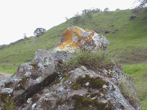
lichen covered rock
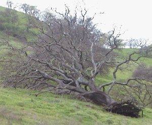
fallen, but alive!
Note the fallen oak on your left. It fell over in 1985 but has remained alive since the root system has not been severed.
Turn to your right and follow the narrow path just after you pass through the gate on the road. This meadow, on the backside of Fossil Hill, is full of Blue-eyed Grass, Curly-Leafed Soap Plant, Geraniums, and Buttercups in the spring. Vetch is taking over this area, fast but sure. Note the several gopher (ground squirrel?) holes. The small creek at the base of this hill drains an area of about one square mile. In this watershed are two ponds, both man made. The upper one ahead of you is Bramhall Pond and the one between you and Indian Valley School is Indian Pond. These ponds, in the spring, teem with thousands of frogs and pollywogs and are magnets to dogs off leash. In the fall/winter, the frogs hibernate in the dried mud, only to emerge again when the rains come.
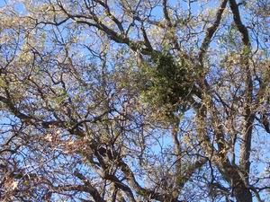
Mistletoe
Also note the many oak galls. If you get the chance to get close to an oak branch, you can see up to a half dozen types of oak galls. These galls form when one of several types of oak-gall moths deposit eggs (through its ovipositor) into either a leaf or bark. This excites the oak as it tries to heal its wound by adding more plant material much like a scar over a wound. Galls are not damaging to a tree, but sit there benignly. Then the larva emerges from the egg and starts to eat its way out. The larva turns into another oak-gall moth and the cycle continues. If you find a green gall, cut it open and find the wriggling larva.
Note the bunch grass clumps along on the right side of the trail. The root system for this grass can reach many feet down to a source of water. Therefore, it stays green all summer long and provides nourishment for several small mammals.
Several kinds of lichens may be seen on the larger oaks. Again, these lichens are not damaging the tree, but only use the tree as a substrate.
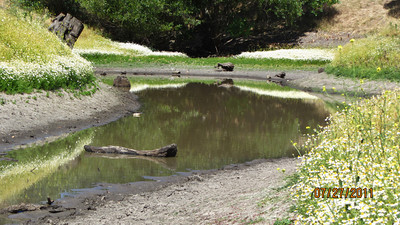
Indian Valley Pond, another beautiful landmark and native habitat restoration area that can be seen on this trail loop
Jerry Fritzke
2003